South Korea: Tectonic Plates & Plate Boundaries
Tectonics: Extensive “geological processes that” disfigure Earth’s lithosphere
(creating land forms that include continents, ocean basins or mountains.) [p.33]
However, tectonic plates is accountable for most destructive natural hazards
(ex. Major tectonic plates include volcanoes and earthquakes that connect to plate boundaries. ) [p.34]
Major Tectonic Plates
Major Tectonic Plate (Lithosphere Plate) are Eurasian Plate, which South Korea is located in it.
Below the tectonic plate map and the black outline arrow, which it show where South Korea is.
White triangle is active volcanoes, colors dots is earthquake, and light blue line with triangle attachment is subduction zones.
Also, the black line is major tectonic plates.
Eurasian Plate (Europe-Asia Plate) for South Korea
Link here at: http://earthguide.ucsd.edu/eoc/teachers/t_tectonics/p_map_plate_layers_bath.html
Minor Tectonic Plates
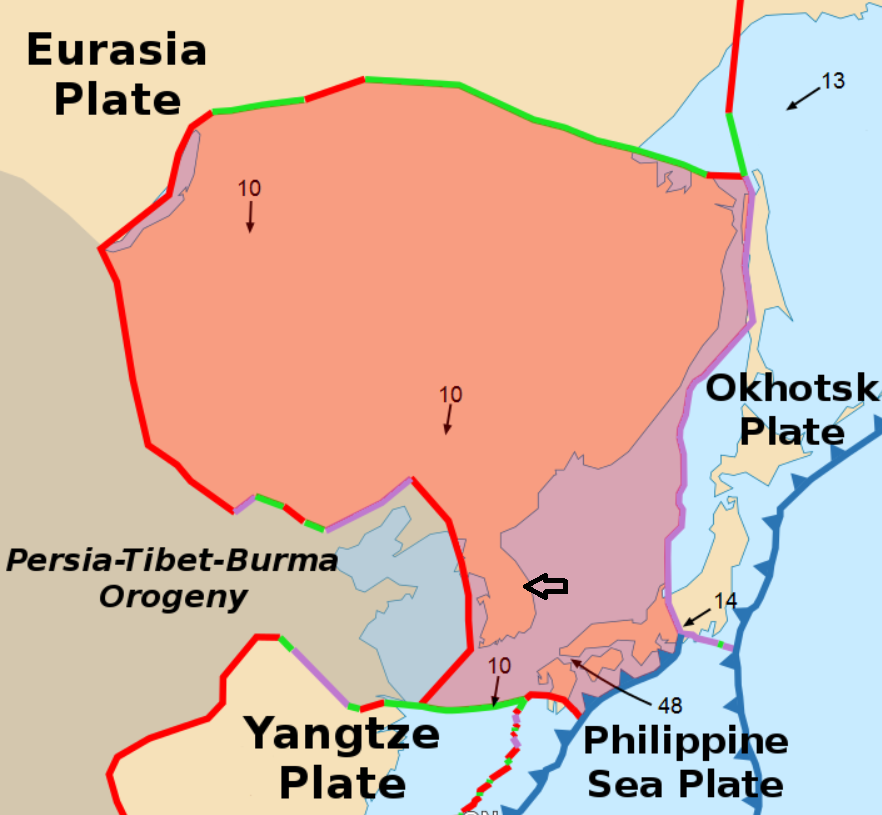
Minor Tectonic Plate is Amurian Plate (Amur Plate). Below the picture and Amurian Plate shown faded red shade. The black outline arrows indicate where South Korea is in both pictures. First and last picture demonstrate that red line present “continental rift boundary/ oceanic spreading ridge” (Divergent boundaries).
Amurian (minor plate) is part of the faded red shade

Link here at: https://en.wikipedia.org/wiki/Amurian_Plate
Amurian Plate

Link here at: https://upload.wikimedia.org/wikipedia/commons/b/bf/Tectonic_plates_boundaries_detailed-en.svg
Minor Tectonic Plates
Minor Tectonic Plate is Amurian Plate (Amur Plate). Below the picture and Amurian Plate shown faded red shade. The black outline arrows indicate where South Korea is in both pictures. First and last picture demonstrate that red line present “continental rift boundary/ oceanic spreading ridge” (Divergent boundaries).
Amurian (minor plate) is part of the faded red shade
Link here at: https://en.wikipedia.org/wiki/Amurian_Plate
Amurian Plate
Link here at: https://upload.wikimedia.org/wikipedia/commons/b/bf/Tectonic_plates_boundaries_detailed-en.svg
Most likely hazards will be earthquakes on the boundary toward South Korea because of the line show boundary on land and ocean.
(clearly shown map)
There Korean article show the earthquakes in Korean Peninsula (which is South and North Korea), here link at http://www.koreatimes.co.kr/www/nation/2017/11/371_238500.html
Works Cited
Keller, A. Edward, and Duane E. DeVecchio. Natural Hazards: Earth's Processes as Hazards, Disasters, and Catastrophes. 4th ed., Pearson Education, 2015. Print.

Comments
Post a Comment